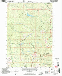
2004 Map of Chilcoot Peak
USGS Topo · Published 2007About this map
The high-elevation landscape of the Boise National Forest centers on the drainage basins of Riordan Creek and its many forks. This area, largely preserved within the Frank Church-River of No Return Wilderness, shows the intricate relationship between early twentieth-century extraction and later conservation efforts. Significant peaks like Chilcoot Peak and Trapper Mountain dominate the skyline, while human activity is evidenced by the presence of the Springfield Mine and the winding path of the Old Mountain Road. Fire management infrastructure is visible at the Meadow Creek Lookout, situated near the boundary with the Cascade Ranger District. The map details a network of alpine water bodies, including Riordan Lake, Black Lake, and Chilcoot Lake, which feed the remote tributaries of the Middle and South Forks of Riordan Creek.
Find a feature on this map
38 named features on this map. Tap any name to fly to it.
Don’t see what you’re looking for? This feature index may not catch every label — zoom into the map to look around manually.
Map Details
Editions of this 2004 Chilcoot Peak Map
This is the sole edition of this map. No revisions or reprints were ever made.
Other maps of this area

1937 · Yellow Pine
USGS Topo · 1:48,000

1943 · Yellow Pine
USGS Topo · 1:62,500

1954 · Warm Lake
USGS Topo · 1:62,500

1957 · Challis
USGS Topo · 1:250,000

1960 · Challis
USGS Topo · 1:250,000

1961 · Chinook Mtn
USGS Topo · 1:62,500

1963 · Challis
USGS Topo · 1:250,000
1973 · Big Chief Creek
USGS Topo · 1:24,000
1973 · Chilcoot Peak
USGS Topo · 1:24,000
1973 · Yellow Pine
USGS Topo · 1:24,000