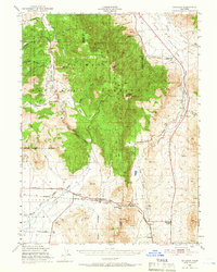
1950 Map of Chilcoot
USGS Topo · Published 1966About this map
The Dixie Mountains dominate this 1950s landscape, where the high-altitude terrain of the Plumas National Forest meets the arid basins along the California-Nevada border. This area is defined by the historic crossing at Beckwourth Pass, a critical low-elevation point in the Sierra Nevada that facilitated the route of the Western Pacific railroad. Small settlements and ranching hubs like Vinton and Chilcoot are clustered in the more accessible valleys, while higher elevations are marked by landmarks such as Adams Peak and Crystal Peak. The map illustrates a transitional geography where timber-rich slopes give way to the drainage of Long Valley Creek. Local history is preserved in the locations of the Summit Sch, a small Cem near Chilcoot, and the rail-dependent community at Reno Junction.
Find a feature on this map
32 named features on this map. Tap any name to fly to it.
Don’t see what you’re looking for? This feature index may not catch every label — zoom into the map to look around manually.
Map Details
Editions of this 1950 Chilcoot Map
5 editions found

Other maps of this area

1886 · Honey Lake
USGS Topo · 1:250,000

1886 · Granite Range
USGS Topo · 1:250,000

1890 · Sierraville
USGS Topo · 1:125,000

1891 · Honey Lake
USGS Topo · 1:250,000

1891 · Reno
USGS Topo · 1:125,000

1892 · Sierraville
USGS Topo · 1:125,000

1893 · Honey Lake
USGS Topo · 1:250,000

1893 · Reno
USGS Topo · 1:125,000

1894 · Granite Range
USGS Topo · 1:250,000

1894 · Sierraville
USGS Topo · 1:125,000