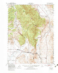
1950 Map of Chilcoot
USGS Topo · Published 1993About this map
Beckwourth Pass serves as a critical geographic gateway on this mid-century survey, marking the lowest point through the Sierra Nevada range for the Western Pacific railroad and regional travel. The landscape is defined by the high-elevation peaks of the Plumas National Forest, including Adams Peak and Crystal Peak, which overlook a network of high-desert valleys. Settlement is concentrated along the rail corridor, where small hubs like Vinton, Chilcoot, and Reno Junction facilitate movement toward the Nevada border.
Find a feature on this map
32 named features on this map. Tap any name to fly to it.
Don’t see what you’re looking for? This feature index may not catch every label — zoom into the map to look around manually.
Map Details
Editions of this 1950 Chilcoot Map
5 editions found

Other maps of this area

1886 · Honey Lake
USGS Topo · 1:250,000

1886 · Granite Range
USGS Topo · 1:250,000

1890 · Sierraville
USGS Topo · 1:125,000

1891 · Honey Lake
USGS Topo · 1:250,000

1891 · Reno
USGS Topo · 1:125,000

1892 · Sierraville
USGS Topo · 1:125,000

1893 · Honey Lake
USGS Topo · 1:250,000

1893 · Reno
USGS Topo · 1:125,000

1894 · Granite Range
USGS Topo · 1:250,000

1894 · Sierraville
USGS Topo · 1:125,000