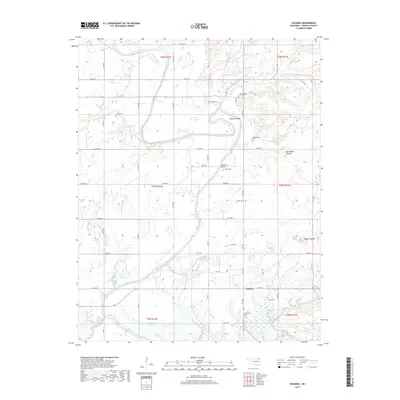
2019 Map of Childers
USGS Topo · Published 2019About this map
The Verdigris River carves a winding path through this portion of Nowata County, creating prominent topographical landmarks like Hancock Bend and providing a focal point for the surrounding rural landscape. This 2019 survey documents the settlement of Childers, where the intersection of local roads meets the river's influence. Family and community history is preserved across numerous burial sites scattered throughout the terrain, including Childers Cem, Lowrey Cem, and the Goodtraveler Cem. Notable elevations such as Steamboat Mound and Tully Hill break the landscape, while the river is spanned by the Hancock Bridge. The presence of several small lakes like Stone Lake and Taylor Lake further defines the local geography, illustrating the enduring relationship between the community and its water resources in northeastern Oklahoma.
Find a feature on this map
43 named features on this map. Tap any name to fly to it.
Don’t see what you’re looking for? This feature index may not catch every label — zoom into the map to look around manually.
Map Details
Editions of this 2019 Childers Map
This is the sole edition of this map. No revisions or reprints were ever made.
Other maps of this area

1901 · Nowata
USGS Topo · 1:125,000

1901 · Vinita
USGS Topo · 1:125,000

1913 · Vinita
USGS Topo · 1:125,000

1914 · Nowata
USGS Topo · 1:125,000

1954 · Tulsa
USGS Topo · 1:250,000

1958 · Tulsa
USGS Topo · 1:250,000

1963 · Tulsa
USGS Topo · 1:250,000
1972 · Elliott
USGS Topo · 1:24,000

1972 · Nowata West
USGS Topo · 1:24,000
1972 · Sanders
USGS Topo · 1:24,000