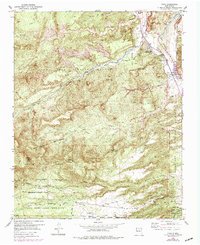
1953 Map of Chili
USGS Topo · Published 1979About this map
The Chama River valley anchors this mid-century topographic record, where small settlements like Chili and La Chuachia are established along the fertile banks of the Rio Chama. The map captures a complex landscape of land grants and administrative boundaries, including the Juan Jose Lobato Grant and the Santa Clara Pueblo Grant. To the west and south, the terrain rises into the Santa Fe National Forest and the Santa Clara Indian Reservation, defined by a series of deep drainage systems like Arroyo del Oso and Arroyo de la Plaza Larga. Industrial activity is noted by a Pumice Pit, while local landmarks like the Immaculate Conception Ch and Clara Lookout Peak provide specific points of interest for genealogists and regional historians. A network of jeep trails through the canyons illustrates the era's rural accessibility before modern development.
Find a feature on this map
30 named features on this map. Tap any name to fly to it.
Don’t see what you’re looking for? This feature index may not catch every label — zoom into the map to look around manually.
Map Details
Editions of this 1953 Chili Map
Other maps of this area

1892 · Santa Clara
USGS Topo · 1:125,000

1918 · Abiquiu
USGS Topo · 1:125,000

1952 · Puye
USGS Topo · 1:24,000

1952 · Guaje Mountain
USGS Topo · 1:24,000

1953 · Espanola
USGS Topo · 1:24,000

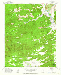
1953 · Chili
USGS Topo · 1:24,000

1953 · Abiquiu
USGS Topo · 1:24,000

1953 · Medanales
USGS Topo · 1:24,000

1953 · Vallecitos
USGS Topo · 1:24,000

1953 · San Juan Pueblo
USGS Topo · 1:24,000