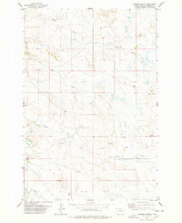
1978 Map of Chimney Butte
USGS Topo · Published 1978About this map
Lola Butte and Chimney Butte rise above a landscape defined by an intricate network of seasonal drainage and early prairie infrastructure in northwestern South Dakota. The survey shows the winding course of the Little Missouri River as it cuts through the southwestern corner, joined by tributaries such as Kimble Creek and Middle Creek. This area of Harding County reveals the spatial distribution of early ranching and community life through features like Ladner Cem and Hoiland Cem, alongside remote Landing Strips and local resource extraction at the Scoria Pit and various sandpits. The presence of numerous wells and springs underscores the importance of water management in this arid cattle country, while the topographical detail highlights unique geological formations like Devils Half Acre near the eastern boundary.
Find a feature on this map
19 named features on this map. Tap any name to fly to it.
Don’t see what you’re looking for? This feature index may not catch every label — zoom into the map to look around manually.
Map Details
Editions of this 1978 Chimney Butte Map
This is the sole edition of this map. No revisions or reprints were ever made.
Other maps of this area

1935 · Buffalo
USGS Topo · 1:125,000

1954 · Lemmon
USGS Topo · 1:250,000

1957 · Lemmon
USGS Topo · 1:250,000

1969 · Table Mountain
USGS Topo · 1:24,000

1969 · Ladner
USGS Topo · 1:24,000
1971 · Lahti Butte
USGS Topo · 1:24,000

1973 · Gallup Creek
USGS Topo · 1:24,000

1974 · Caroline Butte
USGS Topo · 1:24,000
1977 · Scott Creek
USGS Topo · 1:24,000
1977 · Doaks Butte
USGS Topo · 1:24,000