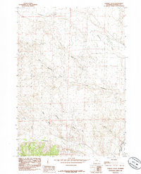
1985 Map of Chimney Gulch
USGS Topo · Published 1985About this map
The Bighorn River borders this high desert terrain in Washakie County, where a complex network of ephemeral drainage systems carves through the landscape. This 1985 survey, based on aerial data from the mid-1970s, illustrates the vital role of water management in the arid West, featuring the Bluff Canal running parallel to the river's course. The interior is defined by deep incisions like Chimney Gulch and Lester Draw, which feed into the larger basins of Gooseberry Creek and Cottonwood Creek. To the east, the plateau levels out at Tie Down Flats, reflecting the traditional open-range character of the region. This document serves as a precise record of the topography and drainage patterns before modern land-use shifts altered the visibility of these distinct natural landmarks.
Find a feature on this map
11 named features on this map. Tap any name to fly to it.
Don’t see what you’re looking for? This feature index may not catch every label — zoom into the map to look around manually.
Map Details
Editions of this 1985 Chimney Gulch Map
This is the sole edition of this map. No revisions or reprints were ever made.
Other maps of this area

1914 · Blue Mesa
USGS Topo · 1:62,500

1916 · Blue Mesa
USGS Topo · 1:62,500

1945 · Kirby
USGS Topo · 1:62,500

1946 · Kirby
USGS Topo · 1:62,500

1951 · Dutch Nick Flat
USGS Topo · 1:24,000

1951 · Schuster Flats
USGS Topo · 1:24,000

1951 · Schuster Flats SE
USGS Topo · 1:24,000

1955 · Cody
USGS Topo · 1:250,000

1955 · Thermopolis
USGS Topo · 1:250,000

1958 · Cody
USGS Topo · 1:250,000