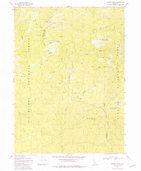
1981 Map of Chimney Rock
USGS Topo · Published 1981About this map
Siskiyou Mine sits high in the mountainous terrain where the borders of Six Rivers National Forest and Klamath National Forest meet. This 1981 survey documents a landscape defined by deep drainages and sharp ridges, notably Buck Camp Ridge and peaks like Sawtooth Mtn and the namesake Chimney Rock. The presence of several historic locations, including Rose Camp (Site) and Dillon Camp (Site), indicates the area's legacy of seasonal habitation or early industrial activity.
Find a feature on this map
29 named features on this map. Tap any name to fly to it.
Don’t see what you’re looking for? This feature index may not catch every label — zoom into the map to look around manually.
Map Details
Editions of this 1981 Chimney Rock Map
This is the sole edition of this map. No revisions or reprints were ever made.
Other maps of this area

1922 · Preston Peak
USGS Topo · 1:125,000

1925 · Hoopa
USGS Topo · 1:125,000

1945 · Ship Mountain
USGS Topo · 1:62,500

1945 · Tectah Creek
USGS Topo · 1:62,500

1948 · Weed
USGS Topo · 1:250,000

1950 · Weed
USGS Topo · 1:250,000

1952 · Ship Mountain
USGS Topo · 1:62,500

1952 · Orleans
USGS Topo · 1:62,500

1952 · Tectah Creek
USGS Topo · 1:62,500

1955 · Dillon Mtn
USGS Topo · 1:62,500