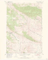
1951 Map of Chimney Rock
USGS Topo · Published 1970About this map
The high ridges of Gallatin National Forest dominate this 1951 topographic study, where local industry and ranching meet the steep slopes of Wineglass Mountain and Pine Mountain. The map details a period of transition for the area's mineral extraction, specifically noting the Maxey Mine and Maxey Mines as inactive by the time of the field check. This shift in economic activity is contrasted by the established presence of the Hoffman School (Maxey School) and local agricultural holdings like the Blome Ranch and Nesbit Ranch. Water management is a visible priority in the lower elevations, where the Briscoe Ditch, Highline Ditch, and Park Branch Canal indicate the importance of irrigation to the drainage basins of Strickland Creek and Maxey Creek. Significant landmarks like The Hogback and Chimney Rock serve as primary navigational points in this complex terrain.
Find a feature on this map
31 named features on this map. Tap any name to fly to it.
Don’t see what you’re looking for? This feature index may not catch every label — zoom into the map to look around manually.
Map Details
Editions of this 1951 Chimney Rock Map
3 editions found
Other maps of this area

1891 · Livingston
USGS Topo · 1:250,000

1893 · Livingston
USGS Topo · 1:250,000

1947 · Bozeman
USGS Topo · 1:250,000

1948 · Bozeman
USGS Topo · 1:250,000

1951 · Bozeman Pass
USGS Topo · 1:62,500

1951 · Brisbin
USGS Topo · 1:24,000

1951 · Hoppers
USGS Topo · 1:24,000

1951 · Chimney Rock
USGS Topo · 1:24,000
1951 · Livingston
USGS Topo · 1:24,000

1955 · Bozeman
USGS Topo · 1:250,000