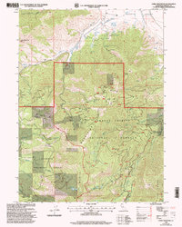
1998 Map of China Mountain
USGS Topo · Published 2003About this map
Scott Mountains and the dramatic ridgelines of The Eddys anchor this high-altitude landscape in the late 1990s. The terrain is defined by its industrial history and conservation status, spanning the Shasta Trinity National Forests and Klamath National Forest. Evidence of historical extraction is prominent, with numerous Prospect sites and the established Richter Mine and Dewey Mine situated near South Fork.
Find a feature on this map
31 named features on this map. Tap any name to fly to it.
Don’t see what you’re looking for? This feature index may not catch every label — zoom into the map to look around manually.
Map Details
Editions of this 1998 China Mountain Map
This is the sole edition of this map. No revisions or reprints were ever made.
Other maps of this area

1886 · Shasta
USGS Topo · 1:250,000

1894 · Shasta
USGS Topo · 1:250,000

1921 · Shasta Valley Sheet No 7
USGS Topo · 1:24,000

1921 · Shasta Valley Sheet No 1
USGS Topo · 1:24,000

1922 · Shasta Valley Sheet No 1 S
USGS Topo · 1:24,000
1922 · Shasta Valley Sheet No 8
USGS Topo · 1:24,000

1923 · Sawyers Bar
USGS Topo · 1:125,000

1931 · Etna
USGS Topo · 1:96,000

1932 · Yreka
USGS Topo · 1:96,000

1934 · Etna
USGS Topo · 1:125,000