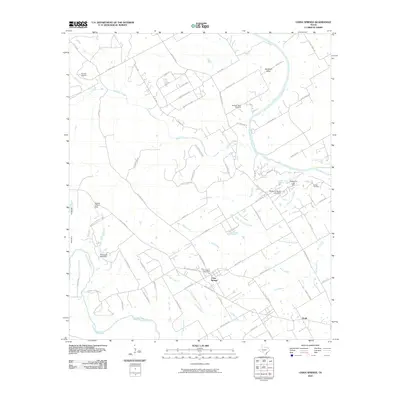
2010 Map of China Springs
USGS Topo · Published 2010About this map
China Springs and the small community of Erath serve as the primary focal points in this central Texas landscape, situated between the winding Brazos River to the east and the North Bosque River to the southwest. The area is defined by its numerous waterways, including Childress Creek and Live Oak Creek, which drain into the larger river systems. A network of rural farm-to-market roads and local lanes, such as China Spring Rd and Wortham Bend Rd, connects the scattered residences and landmarks. Notable local history sites include the China Spring Post Office, Wortham Bend Cemetery, and Patrick Cemetery. Aviation is represented by the Pocock Airport and Wildcat Canyon Strip, while several small reservoirs created by the Thompson Lake Dam and Mahoney South Lake Dam dot the terrain. The topography varies from the flat river basins to the more varied relief of Wildcat Canyon and Lost Hunters Canyon.
Find a feature on this map
80 named features on this map. Tap any name to fly to it.
Don’t see what you’re looking for? This feature index may not catch every label — zoom into the map to look around manually.
Map Details
Editions of this 2010 China Springs Map
This is the sole edition of this map. No revisions or reprints were ever made.
Other maps of this area

1892 · Waco
USGS Topo · 1:125,000

1920 · Waco
USGS Topo · 1:125,000

1924 · Waco 4-c
USGS Topo · 1:48,000

1924 · Waco 3-d
USGS Topo · 1:48,000

1931 · Whitney
USGS Topo · 1:62,500

1931 · Valley Mills
USGS Topo · 1:62,500

1931 · Elm Mott
USGS Topo · 1:62,500

1954 · Waco
USGS Topo · 1:250,000

1955 · Waco
USGS Topo · 1:250,000
1957 · Aquilla
USGS Topo · 1:24,000