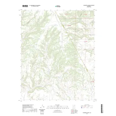
2023 Map of Chinaberry Canyon
USGS Topo · Published 2023About this map
Bueyeros Creek and Mule Creek wind through this high-desert terrain, where the management of water is the primary human imprint on the land. The landscape is defined by an extensive network of named stock tanks, including Antelope Tank, Turkey Tank, and Upper Rattlesnake Tank, which supported ranching operations across the San Miguel and Harding county line. The topography is deeply incised by major drainages like Chinaberry Canyon and Bueyeros Canyon, revealing the erosive power of seasonal flows in this part of New Mexico. Local transport is limited to established ranch roads such as Newberry Rd and Trigg Rd, which connect the isolated tanks and canyons of the high plains plateau. The map serves as a detailed record of the essential infrastructure required for survival and industry in a semi-arid environment.
Find a feature on this map
30 named features on this map. Tap any name to fly to it.
Don’t see what you’re looking for? This feature index may not catch every label — zoom into the map to look around manually.
Map Details
Editions of this 2023 Chinaberry Canyon Map
This is the sole edition of this map. No revisions or reprints were ever made.
Other maps of this area

1954 · Santa Fe
USGS Topo · 1:250,000

1954 · Tucumcari
USGS Topo · 1:250,000

1958 · Santa Fe
USGS Topo · 1:250,000

1958 · Tucumcari
USGS Topo · 1:250,000

1969 · Salitre Canyon
USGS Topo · 1:24,000
1969 · Alamosa Canyon
USGS Topo · 1:24,000
1969 · Campana
USGS Topo · 1:24,000

1969 · Chinaberry Canyon
USGS Topo · 1:24,000
1972 · Bell Ranch
USGS Topo · 1:24,000

1972 · Waggoner Ranch
USGS Topo · 1:24,000