1984 Map of Chincoteague
USGS Topo · Published 1984About this map
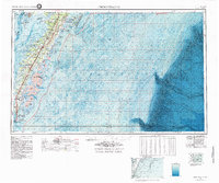
The Delmarva Peninsula's southern reach is defined by a complex network of barrier islands and tidal estuaries on this 1984 topographic-bathymetric survey. Settlements like Tangier and Wachapreague appear alongside the vital transport corridor of the Pennsylvania RR and Route 13. This map captures a significant era of technological and conservation presence on the Eastern Shore, featuring the Wallops Flight Facility (NASA) and Cape Charles Air Force Sta alongside protected lands such as the Martin Nat Wildlife Refuge. From the deep waters of the Atlantic Ocean to the protected reaches of Chincoteague Bay, the bathymetric data illustrates the submarine shelf that has shaped the region's maritime economy. Smaller inland hamlets like Temperanceville, Mappsville, and Locustville provide specific points of interest for genealogists tracing family histories across Accomac and Northampton counties during the late twentieth century.
Find a feature on this map
92 named features on this map. Tap any name to fly to it.
Don’t see what you’re looking for? This feature index may not catch every label — zoom into the map to look around manually.
Map Details
Editions of this 1984 Chincoteague Map
2 editions found

