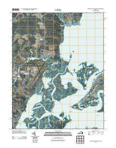
2011 Map of Chincoteague West
USGS Topo · Published 2011About this map
Chincoteague Island and its surrounding coastal waters dominate this Eastern Shore landscape, revealing a complex network of marshes, guts, and narrows. The area serves as a critical hub for maritime activity and scientific research, anchored by the Wallops Flight Facility Airport and academic outposts including the University of Virginia Eastern Shore Branch and Old Dominion University - Wallops Island. Along the mainland, small communities like Horntown and Wattsville maintain a traditional presence, connected to the water via Horntown Landing. The intricate hydrography of Chincoteague Bay is detailed through features like Simoneaston Bay and Queen Sound Channel, illustrating the delicate balance between the mainland and the barrier islands of Wallops Island and Assateague Island.
Find a feature on this map
74 named features on this map. Tap any name to fly to it.
Don’t see what you’re looking for? This feature index may not catch every label — zoom into the map to look around manually.
Map Details
Editions of this 2011 Chincoteague West Map
This is the sole edition of this map. No revisions or reprints were ever made.
Other maps of this area

1901 · Snow Hill
USGS Topo · 1:62,500

1942 · Chincoteague East
USGS Topo · 1:24,000

1942 · Mappsville
USGS Topo · 1:24,000

1942 · Wallops Island
USGS Topo · 1:24,000

1943 · Boxiron
USGS Topo · 1:31,680

1943 · Mappsville
USGS Topo · 1:31,680

1943 · Chincoteague West
USGS Topo · 1:31,680
1943 · Girdletree
USGS Topo · 1:31,680
1943 · Hallwood
USGS Topo · 1:31,680
1943 · Pocomoke City
USGS Topo · 1:31,680