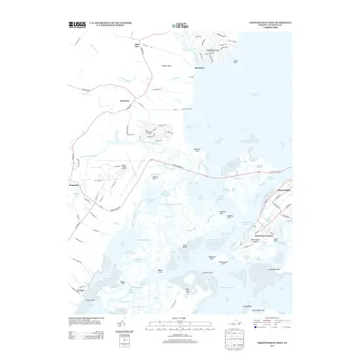
2013 Map of Chincoteague West
USGS Topo · Published 2013About this map
Wallops Flight Facility dominates the interior landscape of this coastal Virginia survey, marking a significant aerospace footprint along the Eastern Shore. The map documents the intricate salt marshes and tidal channels that separate the mainland from Chincoteague Island, including the complex waterways of Simoneaston Bay and the Upper Simoneaston Thorofare. Land use ranges from the established settlements of Horntown and Wattsville to the residential development at Captains Cove with its nautically-themed street names like Blackbeard Dr and Dreadnaught Dr. Researchers can trace the narrow corridors of Little Mosquito Creek and Cockle Creek as they weave through Winders Neck and Wallops Neck. The topography is defined by low-lying coastal features such as Doghead Flat and Shoaling Point, illustrating the delicate balance between land and sea near Assateague Island.
Find a feature on this map
127 named features on this map. Tap any name to fly to it.
Don’t see what you’re looking for? This feature index may not catch every label — zoom into the map to look around manually.
Map Details
Editions of this 2013 Chincoteague West Map
This is the sole edition of this map. No revisions or reprints were ever made.
Other maps of this area

1901 · Snow Hill
USGS Topo · 1:62,500

1942 · Chincoteague East
USGS Topo · 1:24,000

1942 · Mappsville
USGS Topo · 1:24,000

1942 · Wallops Island
USGS Topo · 1:24,000

1943 · Boxiron
USGS Topo · 1:31,680

1943 · Mappsville
USGS Topo · 1:31,680

1943 · Chincoteague West
USGS Topo · 1:31,680
1943 · Girdletree
USGS Topo · 1:31,680
1943 · Hallwood
USGS Topo · 1:31,680
1943 · Pocomoke City
USGS Topo · 1:31,680