
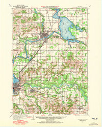
1934 Map of Chippewa Falls
USGS Topo · Published 1967About this map
Chippewa Falls serves as a central hub in this survey, situated at the confluence of the Chippewa River and the Lake Wissota reservoir. The landscape is defined by the heavy infrastructure of the era, including the Minneapolis St Paul and Sault Ste Marie and Chicago St Paul Minneapolis and Omaha railroads. Beyond the urban centers of Eau Claire and Altoona, the countryside is densely dotted with family-named district schools like Rheingans Sch, Thomsen Sch, and Gower Sch, indicating a well-established agrarian community. The presence of the Northern Wisconsin Training School and institutional landmarks like the Seymour Town Hall reflect the region's civic development during the 1930s. Notable water features such as Dells Pond and the Eau Claire River highlight the hydraulic history of these industrial river towns before later 20th-century expansions.
Find a feature on this map
76 named features on this map. Tap any name to fly to it.
Don’t see what you’re looking for? This feature index may not catch every label — zoom into the map to look around manually.
Map Details
Editions of this 1934 Chippewa Falls Map
2 editions found
Other maps of this area

1927 · Strum
USGS Topo · 1:62,500

1930 · Strum
USGS Topo · 1:62,500

1932 · Mondovi
USGS Topo · 1:62,500

1934 · Elk Mound
USGS Topo · 1:62,500

1935 · Osseo
USGS Topo · 1:48,000

1936 · Chippewa Falls
USGS Topo · 1:62,500

1936 · Elk Mound
USGS Topo · 1:62,500

1940 · Osseo
USGS Topo · 1:62,500

1949 · Bloomer
USGS Topo · 1:62,500

1949 · New Auburn
USGS Topo · 1:62,500