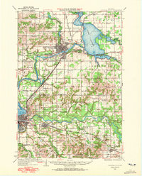
1934 Map of Chippewa Falls
USGS Topo · Published 1972About this map
Chippewa River and the Eau Claire River dominate this landscape, meeting in a region defined by early 20th-century hydraulic development and railway expansion. The massive Lake Wissota spreads across the east, created by the damming of the river, while the city of Chippewa Falls serves as a primary industrial hub. This era shows a dense network of rural infrastructure, including a remarkable number of country schools such as Wood Sch, Eagle Sch, and Frederick Sch, which served the farming communities of Hallie and Tilden.
Find a feature on this map
69 named features on this map. Tap any name to fly to it.
Don’t see what you’re looking for? This feature index may not catch every label — zoom into the map to look around manually.
Map Details
Editions of this 1934 Chippewa Falls Map
2 editions found
Other maps of this area

1927 · Strum
USGS Topo · 1:62,500

1930 · Strum
USGS Topo · 1:62,500

1932 · Mondovi
USGS Topo · 1:62,500

1934 · Elk Mound
USGS Topo · 1:62,500

1934 · Chippewa Falls
USGS Topo · 1:62,500

1935 · Osseo
USGS Topo · 1:48,000

1936 · Chippewa Falls
USGS Topo · 1:62,500

1936 · Elk Mound
USGS Topo · 1:62,500

1940 · Osseo
USGS Topo · 1:62,500

1949 · Bloomer
USGS Topo · 1:62,500