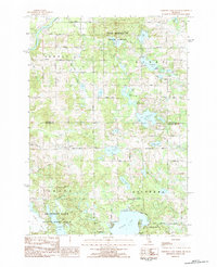
1983 Map of Chippewa Lake North
USGS Topo · Published 1984About this map
The Muskegon River winds through the northwest corner of this 1980s landscape, bordering the Pere Marquette State Forest as it transitions from Hersey into Evart. The region is defined by a dense network of water bodies, from the expansive Chippewa Lake in the south to the developed shoreline of Lake Miramichi. These lakes are joined by smaller basins like Saddlebag Lake, Pogy Lake, and the complex Haymarsh Lakes system within the Haymarsh Lake State Game Area.
Find a feature on this map
53 named features on this map. Tap any name to fly to it.
Don’t see what you’re looking for? This feature index may not catch every label — zoom into the map to look around manually.
Map Details
Editions of this 1983 Chippewa Lake North Map
This is the sole edition of this map. No revisions or reprints were ever made.
Other maps of this area

1954 · Midland
USGS Topo · 1:250,000

1958 · Midland
USGS Topo · 1:250,000

1958 · Big Rapids
USGS Topo · 1:62,500

1959 · Midland
USGS Topo · 1:250,000

1959 · Lake
USGS Topo · 1:62,500

1959 · Evart
USGS Topo · 1:62,500

1964 · Mecosta NW
USGS Topo · 1:24,000

1966 · Midland
USGS Topo · 1:250,000

1976 · Evart SW
USGS Topo · 1:24,000
1976 · Big Rapids NW
USGS Topo · 1:24,000