
1976 Map of Evart SW
USGS Topo · Published 1979About this map
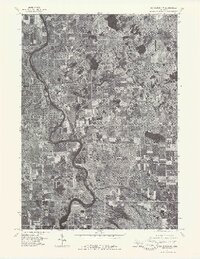
The Muskegon River snakes across this mid-1970s orthophotoquad, its wide, dark channel cutting a deep path through the rural landscape of Mecosta and Osceola counties. Unlike traditional topographic maps, this aerial imagery provides a direct look at the 1976 land use, showing a patchwork of dense woodlots and rectangular agricultural fields. The settlement of Hersey sits at a prominent bend in the river, while the outskirts of Reed City appear in the northwest corner. To the south, the small community of Grant Center is visible amidst the forest and farm clearings. This document captures the region just before significant modern development, preserving the exact layout of roads and homesteads as they existed during the nation's bicentennial year.
Find a feature on this map
4 named features on this map. Tap any name to fly to it.
Don’t see what you’re looking for? This feature index may not catch every label — zoom into the map to look around manually.
Map Details
Editions of this 1976 Evart SW Map
This is the sole edition of this map. No revisions or reprints were ever made.
Other maps of this area

1931 · Chase NE
USGS Topo · 1:31,680

1954 · Midland
USGS Topo · 1:250,000

1958 · Midland
USGS Topo · 1:250,000

1958 · Woodville
USGS Topo · 1:62,500

1958 · Big Rapids
USGS Topo · 1:62,500

1959 · Midland
USGS Topo · 1:250,000

1959 · Evart
USGS Topo · 1:62,500

1959 · Reed City
USGS Topo · 1:62,500

1966 · Midland
USGS Topo · 1:250,000
1976 · Big Rapids NW
USGS Topo · 1:24,000