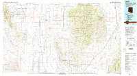
1994 Map of Chiricahua Peak
USGS Topo · Published 1994About this map
The Sulphur Springs Valley defines the western half of this 1994 study, a broad basin where agricultural and residential grid patterns around Sunsites and Pearce stand in contrast to the surrounding mountain ranges. To the east, the Chiricahua Mountains rise sharply, preserved within the Coronado National Forest and the Chiricahua Wilderness. This high-altitude terrain includes unique landmarks like the Chiricahua National Monument and the secluded settlements of Paradise and Portal near the New Mexico border.
Find a feature on this map
40 named features on this map. Tap any name to fly to it.
Don’t see what you’re looking for? This feature index may not catch every label — zoom into the map to look around manually.
Map Details
Editions of this 1994 Chiricahua Peak Map
2 editions found
Other maps of this area

1902 · Bisbee
USGS Topo · 1:62,500

1910 · Bisbee
USGS Topo · 1:62,500

1914 · Hereford
USGS Topo · 1:125,000

1914 · Douglas
USGS Topo · 1:62,500

1915 · Benson
USGS Topo · 1:125,000

1916 · Pearce
USGS Topo · 1:125,000

1916 · Douglas
USGS Topo · 1:125,000

1917 · San Simon
USGS Topo · 1:125,000

1917 · Chiricahua
USGS Topo · 1:125,000

1918 · Cienega Springs
USGS Topo · 1:62,500