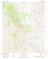
1965 Map of Chise
USGS Topo · Published 1982About this map
Chise and the surrounding high desert of the Sierra Cuchillo range define this 1960s landscape, where small-scale mining and ranching persist in a complex network of canyons. The map documents a cluster of mining claims concentrated along the western slopes, including the Vindicator Mine, Confidence Mines, and the aptly named Prospectors Delight Mine. These extraction points are connected by a system of primitive routes and a Jeep Trail, illustrating the difficult logistics of mid-century prospecting in the New Mexico backcountry.
Find a feature on this map
42 named features on this map. Tap any name to fly to it.
Don’t see what you’re looking for? This feature index may not catch every label — zoom into the map to look around manually.
Map Details
Editions of this 1965 Chise Map
2 editions found
Other maps of this area

1954 · Tularosa
USGS Topo · 1:250,000

1958 · Tularosa
USGS Topo · 1:250,000

1961 · Priest Tank
USGS Topo · 1:24,000

1961 · Williamsburg NW
USGS Topo · 1:24,000

1961 · Monticello
USGS Topo · 1:24,000

1963 · Thumb Tank Peak
USGS Topo · 1:24,000

1963 · Sugarloaf Peak
USGS Topo · 1:24,000

1965 · Winston
USGS Topo · 1:24,000

1965 · Iron Mountain
USGS Topo · 1:24,000

1965 · Jaralosa Mountain
USGS Topo · 1:24,000