
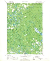
1947 Map of Chittamo
USGS Topo · Published 1956About this map
Chittamo and Stanberry serve as the primary hubs in this mid-century survey of the Wisconsin northwoods, a landscape defined by an intricate network of glacial lakes and wetlands. The drainage of the Totagatic River and its numerous tributaries, including Frog Creek and Black Brook, dominates the central terrain. Settlers and early residents would have navigated this area via the emerging State Highway No 77 and County Highway G, while localized communities were anchored by institutions like the Chittamo Sch and Chippanazie Sch. This 1945 aerial compilation shows the region before significant shoreline development, highlighting many family-named water bodies such as Alexander Lake, Haugen Lake, and Desrosier Lake. The presence of the Totagatic Dam and the expansive Nelson Lake illustrates the early management of these waterways for recreational and environmental purposes in the post-war era.
Find a feature on this map
50 named features on this map. Tap any name to fly to it.
Don’t see what you’re looking for? This feature index may not catch every label — zoom into the map to look around manually.
Map Details
Editions of this 1947 Chittamo Map
2 editions found
Other maps of this area

1944 · Couderay
USGS Topo · 1:48,000

1944 · Drummond
USGS Topo · 1:48,000

1944 · Hayward
USGS Topo · 1:48,000

1945 · Highland
USGS Topo · 1:48,000

1945 · Solon Springs
USGS Topo · 1:48,000

1947 · Drummond
USGS Topo · 1:48,000

1947 · Minong
USGS Topo · 1:48,000

1948 · Couderay
USGS Topo · 1:48,000

1948 · Spooner
USGS Topo · 1:48,000

1948 · Stone Lake
USGS Topo · 1:48,000