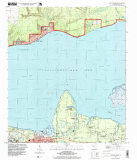
1994 Map of Choctaw Beach
USGS Topo · Published 1999About this map
Choctaw Beach and the expansive northern shores of Choctawhatchee Bay define this mid-1990s landscape in Walton County. The northern portion of the map is dominated by the military presence of Eglin Air Force Base, featuring the Fort Rusker Recreation Area and Grassy Cove. This area illustrates the balance between military land use and recreational waterfront access during this era, showing established roadside landmarks and natural points like Big Hammock Pt.
Find a feature on this map
34 named features on this map. Tap any name to fly to it.
Don’t see what you’re looking for? This feature index may not catch every label — zoom into the map to look around manually.
Map Details
Editions of this 1994 Choctaw Beach Map
This is the sole edition of this map. No revisions or reprints were ever made.
Other maps of this area

1934 · Niceville
USGS Topo · 1:48,000

1935 · Villa Tasso
USGS Topo · 1:48,000

1935 · De Funiak Springs
USGS Topo · 1:48,000

1936 · Niceville
USGS Topo · 1:62,500

1936 · Point Washington
USGS Topo · 1:48,000

1938 · Villa Tasso
USGS Topo · 1:62,500

1938 · De Funiak Springs
USGS Topo · 1:62,500

1939 · Point Washington
USGS Topo · 1:62,500

1956 · Niceville
USGS Topo · 1:62,500

1956 · Villa Tasso
USGS Topo · 1:62,500