
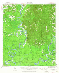
1943 Map of Choctaw Bluff
USGS Topo · Published 1958About this map
The confluence of the Tombigbee River and the Alabama River defines this landscape in southwestern Alabama during the early 1940s. The map reveals a river-driven geography where landings such as Red Eagle Ldg, Dixie Ldg, and Upper Madison Ldg served as vital touchpoints for commerce and transportation. On the eastern side of the confluence, a particularly significant historical site is marked: the Grave of Red Eagle (Weatherford), the final resting place of the Creek leader William Weatherford near Little River Sch.
Find a feature on this map
107 named features on this map. Tap any name to fly to it.
Don’t see what you’re looking for? This feature index may not catch every label — zoom into the map to look around manually.
Map Details
Editions of this 1943 Choctaw Bluff Map
2 editions found
Other maps of this area

1942 · Perdido
USGS Topo · 1:62,500

1943 · Tensaw
USGS Topo · 1:62,500

1943 · Citronelle
USGS Topo · 1:62,500

1943 · McIntosh
USGS Topo · 1:62,500

1944 · McIntosh
USGS Topo · 1:62,500

1944 · Tensaw
USGS Topo · 1:62,500

1944 · Perdido
USGS Topo · 1:62,500

1946 · Citronelle
USGS Topo · 1:62,500

1946 · Choctaw Bluff
USGS Topo · 1:62,500

1953 · Andalusia
USGS Topo · 1:250,000