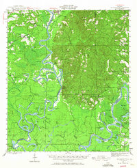
1943 Map of Choctaw Bluff
USGS Topo · Published 1967About this map
Tombigbee River and Alabama River dominate this wartime landscape, creating a complex network of backwaters and bayous such as Big Swamp, Lyman Bayou, and Knee Gut. The survey, conducted during the early 1940s, highlights the river-dependent lifestyle of the era, evidenced by numerous landings like Oven Bluff and Lower Madison Ldg. Deep in the southern reach of the quadrangle lies the Grave of Red Eagle (Weatherford), providing a significant genealogical and historical touchstone for the region.
Find a feature on this map
120 named features on this map. Tap any name to fly to it.
Don’t see what you’re looking for? This feature index may not catch every label — zoom into the map to look around manually.
Map Details
Editions of this 1943 Choctaw Bluff Map
2 editions found
Other maps of this area

1942 · Perdido
USGS Topo · 1:62,500

1943 · Choctaw Bluff
USGS Topo · 1:62,500

1943 · Tensaw
USGS Topo · 1:62,500

1943 · Citronelle
USGS Topo · 1:62,500

1943 · McIntosh
USGS Topo · 1:62,500

1944 · McIntosh
USGS Topo · 1:62,500

1944 · Tensaw
USGS Topo · 1:62,500

1944 · Perdido
USGS Topo · 1:62,500

1946 · Citronelle
USGS Topo · 1:62,500

1946 · Choctaw Bluff
USGS Topo · 1:62,500