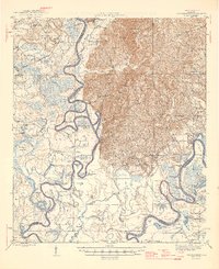
1946 Map of Choctaw Bluff
USGS Topo · Published 1946About this map
The Tombigbee River dominates this mid-century landscape, carving a complex path of oxbows and sloughs through the swampy lowlands of Clarke and Baldwin counties. A notable cultural landmark is the Grave of Red Eagle (Weatherford), marking the final resting place of the Muscogee leader William Weatherford near the river's edge. This area, largely defined by its floodplains and timbered ridges, shows a scatter of rural river settlements and tenant sites such as Harrells Quarters and Austill Pl.
Find a feature on this map
90 named features on this map. Tap any name to fly to it.
Don’t see what you’re looking for? This feature index may not catch every label — zoom into the map to look around manually.
Map Details
Editions of this 1946 Choctaw Bluff Map
2 editions found
Other maps of this area

1942 · Perdido
USGS Topo · 1:62,500

1943 · Choctaw Bluff
USGS Topo · 1:62,500

1943 · Tensaw
USGS Topo · 1:62,500

1943 · Citronelle
USGS Topo · 1:62,500

1943 · McIntosh
USGS Topo · 1:62,500

1944 · McIntosh
USGS Topo · 1:62,500

1944 · Tensaw
USGS Topo · 1:62,500

1944 · Perdido
USGS Topo · 1:62,500

1946 · Citronelle
USGS Topo · 1:62,500

1946 · Choctaw Bluff
USGS Topo · 1:62,500