
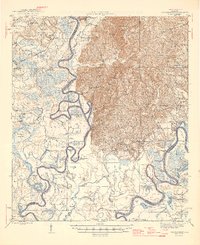
1946 Map of Choctaw Bluff
USGS Topo · Published 1946About this map
The Grave of Red Eagle (Weatherford) sits near the confluence where the Tombigbee River and Alabama River dominate this 1940s Alabama landscape. The region is characterized by a dense network of river-dependent landings and settlements, such as Oven Bluff, Carney Bluff, and Dallas Ldg, reflecting a late-era reliance on these waterways for transport and commerce. Inland, the terrain rises toward Roundtop Hill, where small communities like Rockville and Alma are supported by several country churches and schools, including Christian Valley Sch and Mt Olive Ch. The Southern Railway cuts through the northwest corner near Prestwick, while the bottomlands are a maze of sloughs and lakes like Monger Island and Big Hole Slough, illustrating the seasonal flooding patterns of the deep river basin.
Find a feature on this map
99 named features on this map. Tap any name to fly to it.
Don’t see what you’re looking for? This feature index may not catch every label — zoom into the map to look around manually.
Map Details
Editions of this 1946 Choctaw Bluff Map
2 editions found
Other maps of this area

1942 · Perdido
USGS Topo · 1:62,500

1943 · Choctaw Bluff
USGS Topo · 1:62,500

1943 · Tensaw
USGS Topo · 1:62,500

1943 · Citronelle
USGS Topo · 1:62,500

1943 · McIntosh
USGS Topo · 1:62,500

1944 · McIntosh
USGS Topo · 1:62,500

1944 · Tensaw
USGS Topo · 1:62,500

1944 · Perdido
USGS Topo · 1:62,500

1946 · Citronelle
USGS Topo · 1:62,500

1953 · Andalusia
USGS Topo · 1:250,000