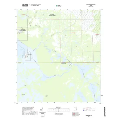
2021 Map of Chokoloskee
USGS Topo · Published 2021About this map
Chokoloskee is the central hub of this coastal Florida landscape, where the land fragmentizes into the vast mangroves and tidal keys of the Ten Thousand Islands. Situated on Chokoloskee Island, this historic fishing community serves as a gateway to the intricate water networks of Everglades National Park and Big Cypress National Preserve. The map illustrates a labyrinthine geography of saltwater bays and narrow tidal creeks, such as Lopez River and Turner River, that have long dictated human movement in this subtropical environment.
Find a feature on this map
60 named features on this map. Tap any name to fly to it.
Don’t see what you’re looking for? This feature index may not catch every label — zoom into the map to look around manually.
Map Details
Editions of this 2021 Chokoloskee Map
This is the sole edition of this map. No revisions or reprints were ever made.
Other maps of this area

1956 · Miami
USGS Topo · 1:250,000

1958 · Miami
USGS Topo · 1:250,000

1972 · Weavers Station
USGS Topo · 1:24,000

1972 · Burns Lake
USGS Topo · 1:24,000

1972 · Ochopee
USGS Topo · 1:24,000

1973 · Gator Hook Swamp
USGS Topo · 1:24,000

1973 · Pavilion Key
USGS Topo · 1:24,000

1973 · Alligator Bay
USGS Topo · 1:24,000
1974 · Everglades City
USGS Topo · 1:24,000
1974 · Chokoloskee
USGS Topo · 1:24,000