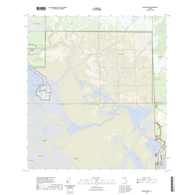
2024 Map of Chokoloskee
USGS Topo · Published 2024About this map
Chokoloskee Island and its surrounding coastal waters anchor this recent survey of the transition between the Florida mainland and the Gulf of Mexico. This environment is characterized by an intricate network of mangrove islands and tidal waterways, part of the Ten Thousand Islands and the Marjory Stoneman Douglas Wilderness. Significant water routes such as the Turner River, Lopez River, and Chokoloskee Pass facilitate movement through the dense wetlands. The map details the modern balance between residential pockets like Plantation Island and the protected lands of Big Cypress National Preserve and Everglades National Park. Recreation is a primary focus of the infrastructure here, represented by the Wilderness Waterway Trl and the Everglades Paddling Trl, which connect remote spots like Sunday Bay and Oyster Bay for modern navigators.
Find a feature on this map
39 named features on this map. Tap any name to fly to it.
Don’t see what you’re looking for? This feature index may not catch every label — zoom into the map to look around manually.
Map Details
Editions of this 2024 Chokoloskee Map
This is the sole edition of this map. No revisions or reprints were ever made.
Other maps of this area

1956 · Miami
USGS Topo · 1:250,000

1958 · Miami
USGS Topo · 1:250,000

1972 · Weavers Station
USGS Topo · 1:24,000

1972 · Burns Lake
USGS Topo · 1:24,000

1972 · Ochopee
USGS Topo · 1:24,000

1973 · Gator Hook Swamp
USGS Topo · 1:24,000

1973 · Pavilion Key
USGS Topo · 1:24,000

1973 · Alligator Bay
USGS Topo · 1:24,000
1974 · Everglades City
USGS Topo · 1:24,000
1974 · Chokoloskee
USGS Topo · 1:24,000