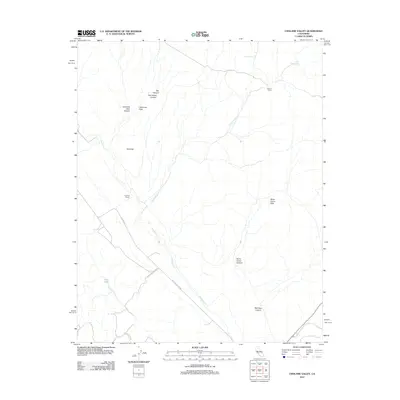
2012 Map of Cholame Valley
USGS Topo · Published 2012About this map
Cholame Ranch and Hancock Ranch anchor this portion of the inner Coast Ranges, where the landscape is defined by the seasonal drainage of Cholame Cr and its tributaries. The topography is marked by significant elevation changes, from the alluvial plains of Stone Corral Flats to the prominent rise of Gold Hill. Water is a critical and concentrated resource here, evidenced by the presence of Kerr Lake, Kerr Spring, and named seeps like Little Tiger Spring and Willow Spring.
Find a feature on this map
20 named features on this map. Tap any name to fly to it.
Don’t see what you’re looking for? This feature index may not catch every label — zoom into the map to look around manually.
Map Details
Editions of this 2012 Cholame Valley Map
This is the sole edition of this map. No revisions or reprints were ever made.
Other maps of this area

1914 · Cholame
USGS Topo · 1:125,000

1915 · Cholame
USGS Topo · 1:125,000

1917 · Cholame
USGS Topo · 1:125,000

1934 · The Dark Hole
USGS Topo · 1:31,680

1934 · Reef Ridge
USGS Topo · 1:31,680
1937 · Reef Ridge
USGS Topo · 1:31,680
1937 · The Dark Hole
USGS Topo · 1:31,680

1942 · Parkfield
USGS Topo · 1:24,000

1942 · Tent Hills
USGS Topo · 1:24,000

1943 · Shandon
USGS Topo · 1:31,680