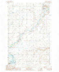
1987 Map of Choteau SE
USGS Topo · Published 1987About this map
The Teton River meanders across this high plains landscape, defining the topography of the northern Missouri River watershed in the late 1980s. The map illustrates a highly managed hydrologic system, where the S-T Canal and various ditches support agriculture across the flat expanse of the Bench. To the south, the Freezout Lake Game Management Area encompasses Freezout Lake, a vital wetland habitat framed by Priest Butte. Cultural features are distinct but sparse, including the New Rockport Colony and the small settlement of Bole. For those interested in historical infrastructure, the presence of an Old RR Grade reveals the path of former rail lines that once served this agricultural region, while coulees like Spring Coulee and Gamble Coulee cut through the terrain toward the river valley.
Find a feature on this map
14 named features on this map. Tap any name to fly to it.
Don’t see what you’re looking for? This feature index may not catch every label — zoom into the map to look around manually.
Map Details
Editions of this 1987 Choteau SE Map
This is the sole edition of this map. No revisions or reprints were ever made.
Other maps of this area

1886 · Great Falls
USGS Topo · 1:250,000

1920 · Choteau
USGS Topo · 1:125,000

1950 · Fairfield
USGS Topo · 1:62,500

1950 · Collins
USGS Topo · 1:62,500

1954 · Great Falls
USGS Topo · 1:250,000

1955 · Choteau
USGS Topo · 1:250,000

1957 · Choteau
USGS Topo · 1:250,000

1957 · Great Falls
USGS Topo · 1:250,000

1958 · Choteau
USGS Topo · 1:250,000

1960 · Choteau
USGS Topo · 1:62,500