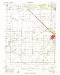
1960 Map of Chowchilla
USGS Topo · Published 1962About this map
Chowchilla serves as the central hub of this Central Valley landscape, situated along the Southern Pacific railroad line where the Merced and Madera county border divides the region. The agricultural character of the era is evident in the sprawling network of named avenues and canal-fed lands, supported by various sloughs and creeks such as Ash Slough and the Chowchilla River. Small settlements and ranching outposts like Athlone, Lingard, and the Mansada Ranch dot the grid, reflecting the intensive irrigation and transit patterns required for San Joaquin Valley farming in the mid-20th century.
Find a feature on this map
65 named features on this map. Tap any name to fly to it.
Don’t see what you’re looking for? This feature index may not catch every label — zoom into the map to look around manually.
Map Details
Editions of this 1960 Chowchilla Map
This is the sole edition of this map. No revisions or reprints were ever made.
Other maps of this area

1913 · Panoche
USGS Topo · 1:125,000

1914 · Merced
USGS Topo · 1:31,680

1915 · Owens Creek
USGS Topo · 1:31,680

1916 · Berenda
USGS Topo · 1:31,680

1916 · Santa Rita Bridge
USGS Topo · 1:24,000

1917 · Merced
USGS Topo · 1:31,680

1918 · Bliss Ranch
USGS Topo · 1:31,680

1918 · Owens Creek
USGS Topo · 1:31,680

1918 · Lingard
USGS Topo · 1:31,680

1918 · Atwater
USGS Topo · 1:31,680