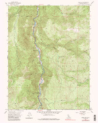
1954 Map of Chris Flat
USGS Topo · Published 1986About this map
West Walker River carves a deep path through the eastern Sierra landscape, anchoring a corridor of historical activity within the Toiyabe National Forest. The map reveals a sequence of flats and meadows that served as early mountain waypoints, including China Garden, Shingle Mill Flat, and Tollhouse Flat. These names suggest a history of early industry and commerce along the river banks, where timber processing and toll collection once facilitated movement through the high country. In the backcountry, topographical markers like VABM Deep 8171 and the Deep Creek Mine point to a landscape of resource extraction and survey work.
Find a feature on this map
34 named features on this map. Tap any name to fly to it.
Don’t see what you’re looking for? This feature index may not catch every label — zoom into the map to look around manually.
Map Details
Editions of this 1954 Chris Flat Map
5 editions found

Other maps of this area

1889 · Markleeville
USGS Topo · 1:125,000

1891 · Markleeville
USGS Topo · 1:125,000

1891 · Wellington
USGS Topo · 1:125,000

1893 · Markleeville
USGS Topo · 1:125,000

1893 · Wellington
USGS Topo · 1:125,000

1896 · Dardanelles
USGS Topo · 1:125,000

1898 · Dardanelles
USGS Topo · 1:125,000

1909 · Bridgeport
USGS Topo · 1:125,000

1911 · Bridgeport
USGS Topo · 1:125,000

1920 · Bridgeport
USGS Topo · 1:125,000