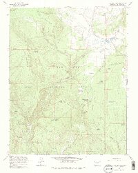
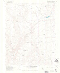
1964 Map of Chris Mountain
USGS Topo · Published 1975About this map
San Juan National Forest defines the character of this mid-1960s landscape, where a sophisticated network of water management features supports high-elevation ranching and forestry. The terrain is marked by significant mesas and canyons, including Brockover Mesa and Dunagan Canyon, with drainage flowing toward Devil Creek. The map documents a specialized infrastructure of small-scale reservoirs such as Sawmill Reservoir, Gopher Reservoir, and Newt Jack Spring Reservoir, likely used for livestock or fire suppression. Human presence is concentrated at sites like the Turkey Springs Guard Station and Turkey Springs Campground, alongside working properties like Snow Angel Ranch and Texas Ranch. A complex system of Jeep Trails and Pack Trails indicates a working landscape of timber and cattle rather than established towns, centered around the prominent Chris Mountain.
Find a feature on this map
37 named features on this map. Tap any name to fly to it.
Don’t see what you’re looking for? This feature index may not catch every label — zoom into the map to look around manually.
Map Details
Editions of this 1964 Chris Mountain Map
5 editions found
Other maps of this area

1924 · Pagosa Springs
USGS Topo · 1:125,000

1927 · Pagosa Springs
USGS Topo · 1:125,000

1945 · Durango
USGS Topo · 1:250,000

1953 · Durango
USGS Topo · 1:250,000

1954 · Durango
USGS Topo · 1:250,000

1957 · Pagosa Junction
USGS Topo · 1:62,500

1961 · Durango
USGS Topo · 1:250,000

1963 · Durango
USGS Topo · 1:250,000
1964 · Chris Mountain
USGS Topo · 1:24,000
1964 · Pagosa Springs
USGS Topo · 1:24,000