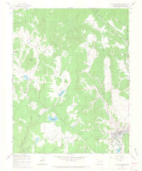
1964 Map of Pagosa Springs
USGS Topo · Published 1967About this map
Pagosa Springs is the focal point of this mid-1960s study, situated at the bend of the San Juan River and serving as the southeastern gateway to the San Juan National Forest. The landscape is defined by its transition from the irrigated valley floors of Sunetha Flats to the timbered heights of Coyote Hill and Oakbrush Hill. Water management is central to the area's development, evidenced by the numerous irrigation ditches and reservoirs like Hatcher Reservoir, Stevens Reservoir, and Sullenburger Reservoir that dot the drainage basins of Martinez Creek and McCabe Creek. The presence of the Pagosa Springs Job Corps and Stevens Airfield reflects the mid-century institutional and infrastructure growth in this part of Archuleta County. Genealogists and local historians can locate the Hilltop Cem and the High Sch, along with numerous named draws and canyons that define the ranching and forest boundary lines of the era.
Find a feature on this map
34 named features on this map. Tap any name to fly to it.
Don’t see what you’re looking for? This feature index may not catch every label — zoom into the map to look around manually.
Map Details
Editions of this 1964 Pagosa Springs Map
3 editions found
Other maps of this area

1913 · Summitville
USGS Topo · 1:125,000

1915 · Summitville
USGS Topo · 1:125,000

1924 · Pagosa Springs
USGS Topo · 1:125,000

1927 · Pagosa Springs
USGS Topo · 1:125,000

1945 · Durango
USGS Topo · 1:250,000

1953 · Durango
USGS Topo · 1:250,000

1954 · Durango
USGS Topo · 1:250,000

1957 · Chromo
USGS Topo · 1:62,500

1957 · Wolf Creek Pass
USGS Topo · 1:62,500

1957 · Pagosa Junction
USGS Topo · 1:62,500