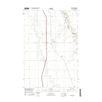
2014 Map of Christine
USGS Topo · Published 2014About this map
Christine serves as the central settlement in this Red River Valley landscape, situated where the expansive North Dakota plains meet the meandering border of Minnesota. The geography is defined by two prominent waterways: the tightly winding Red River of the North, which carves the state boundary to the east, and the Wild Rice River, which snakes through the western half of the quadrangle. This 2014 survey documents a rural infrastructure of gravel roads and section lines, connecting the smaller locales of Lithia and Enloe. For local historians and genealogists, the map is particularly useful for its documentation of numerous burial grounds scattered across the townships, including Christine Cem, Pioneer Cem, and South Pleasant Cem. Transportation and aviation are represented by the presence of CR-81 and the Flying-N-Ranch Airport, illustrating the continued importance of both regional transit and local airfields in this agricultural corridor.
Find a feature on this map
17 named features on this map. Tap any name to fly to it.
Don’t see what you’re looking for? This feature index may not catch every label — zoom into the map to look around manually.
Map Details
Editions of this 2014 Christine Map
This is the sole edition of this map. No revisions or reprints were ever made.
Other maps of this area

1895 · Fargo
USGS Topo · 1:125,000

1897 · Fargo
USGS Topo · 1:125,000

1904 · Wahpeton
USGS Topo · 1:125,000

1953 · Fargo
USGS Topo · 1:250,000

1956 · Fargo
USGS Topo · 1:250,000

1959 · Mooreton NW
USGS Topo · 1:24,000

1959 · Hickson
USGS Topo · 1:24,000
1959 · Walcott
USGS Topo · 1:24,000

1959 · Christine
USGS Topo · 1:24,000
1959 · Norman
USGS Topo · 1:24,000