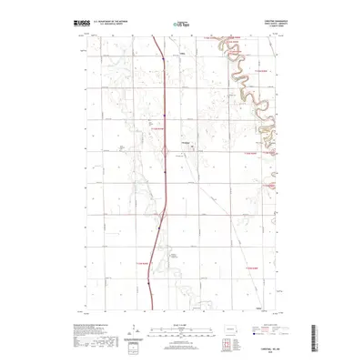
2020 Map of Christine
USGS Topo · Published 2020About this map
The Wild Rice River meanders across this landscape in Richland County, forming a complex drainage pattern that defines the western half of the territory near Christine. To the east, the Red River of the North serves as the natural boundary between North Dakota and Minnesota, its tightly looped oxbows creating a distinctive border between Richland and Wilkin counties. This area is characterized by a high density of small rural burial grounds, which offer significant genealogical value for researching early Red River Valley families. Notable sites include Pioneer Cem and Eagle Cem near the riverbanks, as well as the Richland Lutheran Church Cem further inland. The settlement of Lithia anchors the northern section, while Enloe sits at the southern edge, connected by a grid of agricultural roads such as Co Rd 2 and 58th St SE.
Find a feature on this map
33 named features on this map. Tap any name to fly to it.
Don’t see what you’re looking for? This feature index may not catch every label — zoom into the map to look around manually.
Map Details
Editions of this 2020 Christine Map
This is the sole edition of this map. No revisions or reprints were ever made.
Other maps of this area

1895 · Fargo
USGS Topo · 1:125,000

1897 · Fargo
USGS Topo · 1:125,000

1904 · Wahpeton
USGS Topo · 1:125,000

1953 · Fargo
USGS Topo · 1:250,000

1956 · Fargo
USGS Topo · 1:250,000

1959 · Mooreton NW
USGS Topo · 1:24,000

1959 · Hickson
USGS Topo · 1:24,000
1959 · Walcott
USGS Topo · 1:24,000

1959 · Christine
USGS Topo · 1:24,000
1959 · Norman
USGS Topo · 1:24,000