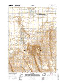
2014 Map of Christmas Valley
USGS Topo · Published 2014About this map
Christmas Valley and its smaller neighbor Christmas Lake Valley sit at the center of a high desert landscape marked by festive road names and an extensive network of water management features. The residential grid is defined by themed thoroughfares like Jingle Bell Rd, Mistletoe Ln, and Holly St, branching out near the Christmas Valley Airport. This developed area contrasts sharply with the complex topography to the south, where the Black Hills and St Patrick Mtn rise above the basin floor.
Find a feature on this map
51 named features on this map. Tap any name to fly to it.
Don’t see what you’re looking for? This feature index may not catch every label — zoom into the map to look around manually.
Map Details
Editions of this 2014 Christmas Valley Map
This is the sole edition of this map. No revisions or reprints were ever made.
Other maps of this area

1955 · Crescent
USGS Topo · 1:250,000

1957 · Crescent
USGS Topo · 1:250,000

1958 · Crescent
USGS Topo · 1:250,000

1970 · Crescent
USGS Topo · 1:250,000

1981 · Thorn Lake
USGS Topo · 1:24,000

1981 · Lane Lake
USGS Topo · 1:24,000

1982 · Christmas Lake
USGS Topo · 1:24,000
1982 · Egli Rim
USGS Topo · 1:24,000
1983 · Crack-in-the-Ground
USGS Topo · 1:24,000

1986 · St. Patrick Mtn.
USGS Topo · 1:24,000