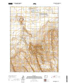
2020 Map of Christmas Valley
USGS Topo · Published 2020About this map
The settlement of Christmas Valley is established along a geometric grid of residential streets such as Elm Ln and Alder St, positioned just north of the notable Sevenmile Ridge. This High Desert landscape is defined by its water management, featuring a series of catchments and named reservoirs including Withers Reservoir, Coffee Pot Reservoir, and Guinee Reservoir Number 3. The local infrastructure is centered around the Christmas Valley Airport and the nearby Christmas Valley Lake, serving as a hub for this remote interior region. To the south, the terrain rises into the Black Hills, where numerous sheep-related water features like Upper Sheep Corral Reservoir and Sheep Corral Reservoir suggest the area's ongoing or historical connection to livestock grazing in the Lake County rangelands.
Find a feature on this map
84 named features on this map. Tap any name to fly to it.
Don’t see what you’re looking for? This feature index may not catch every label — zoom into the map to look around manually.
Map Details
Editions of this 2020 Christmas Valley Map
This is the sole edition of this map. No revisions or reprints were ever made.
Other maps of this area

1955 · Crescent
USGS Topo · 1:250,000

1957 · Crescent
USGS Topo · 1:250,000

1958 · Crescent
USGS Topo · 1:250,000

1970 · Crescent
USGS Topo · 1:250,000

1981 · Thorn Lake
USGS Topo · 1:24,000

1981 · Lane Lake
USGS Topo · 1:24,000

1982 · Christmas Lake
USGS Topo · 1:24,000
1982 · Egli Rim
USGS Topo · 1:24,000
1983 · Crack-in-the-Ground
USGS Topo · 1:24,000

1986 · St. Patrick Mtn.
USGS Topo · 1:24,000