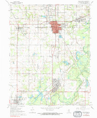
1968 Map of Christopher
USGS Topo · Published 1969About this map
Southern Illinois coal country is centered here in the late 1960s, defined by the industrial and social infrastructure of Christopher and its surrounding mining settlements. The landscape is a network of rail lines including the Illinois Central Railroad and the Missouri Pacific Railroad, which serviced the active extractive economy of Franklin County. Local genealogy is deeply etched into the land through numerous burial grounds like Old Mulkeytown Cem, Knight Cem, and the Miners Cem near Royalton. In Christopher, the presence of the Miners Hospital and the Washington St Andrews Sch reflects the established community life of the mid-20th century. Water management is a visible priority, with the Christopher Reservoir, Zeigler Reservoir, and various sewage disposal ponds supporting the dense residential clusters. To the south, the Big Muddy River meanders through Six Mile township, passing the Royalton Lookout Tower and Super-Kol Park.
Find a feature on this map
82 named features on this map. Tap any name to fly to it.
Don’t see what you’re looking for? This feature index may not catch every label — zoom into the map to look around manually.
Map Details
Editions of this 1968 Christopher Map
2 editions found
Other maps of this area

1909 · West Frankfort
USGS Topo · 1:62,500

1910 · Herrin
USGS Topo · 1:62,500

1926 · Duquoin
USGS Topo · 1:62,500

1936 · Herrin
USGS Topo · 1:62,500

1939 · Ina
USGS Topo · 1:62,500

1941 · West Frankfort
USGS Topo · 1:62,500

1943 · Ina
USGS Topo · 1:62,500

1949 · Paducah
USGS Topo · 1:250,000

1950 · Paducah
USGS Topo · 1:250,000

1954 · Paducah
USGS Topo · 1:250,000