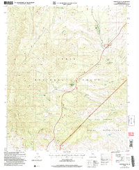
2004 Map of Chrome Butte
USGS Topo · Published 2007About this map
McMillanville (Site) serves as a primary historical anchor on this landscape where the Tonto National Forest meets the San Carlos Apache Reservation. The terrain is defined by significant elevations like Richmond Mountain and the Apache Peaks, which overlook a network of seasonal drainages and vital water points. Life in this arid portion of Gila County is traced through the locations of the Griffin Ranch and Winters Ranch, alongside numerous livestock tanks and wells such as Winters Well and Coburn Tank. The map documents a landscape of unsurveyed protracted blocks, emphasizing the remote nature of the Haystack Butte Road corridor. The presence of Chrome Butte and Chalky Butte highlights the distinct geological character of the region, while the Globe Ranger District boundary marks the administrative transition into the surrounding wilderness.
Find a feature on this map
34 named features on this map. Tap any name to fly to it.
Don’t see what you’re looking for? This feature index may not catch every label — zoom into the map to look around manually.
Map Details
Editions of this 2004 Chrome Butte Map
This is the sole edition of this map. No revisions or reprints were ever made.
Other maps of this area

1901 · Globe
USGS Topo · 1:62,500

1902 · Globe
USGS Topo · 1:62,500

1922 · Chrysotile
USGS Topo · 1:125,000

1945 · Globe
USGS Topo · 1:24,000

1949 · Rockinstraw Mtn
USGS Topo · 1:62,500

1950 · Rockinstraw Mtn
USGS Topo · 1:62,500

1954 · Mesa
USGS Topo · 1:250,000

1957 · Mesa
USGS Topo · 1:250,000

1958 · Mesa
USGS Topo · 1:250,000

1960 · Mesa
USGS Topo · 1:250,000