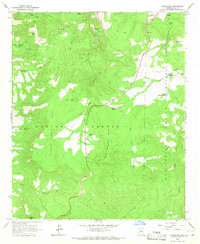
1966 Map of Chrysotile
USGS Topo · Published 1968About this map
The settlement of Chrysotile sits at the heart of this high-elevation landscape, where the northern reaches of the San Carlos Indian Reservation meet the Tonto National Forest. Surveyed in the mid-1960s, the terrain is defined by dramatic peaks like Timber Camp Mountain and Carol Spring Mountain. The presence of a Mine and numerous prospects near the headwaters of Ash Creek point to the area's history of mineral extraction. Water management in this arid region is evidenced by an extensive system of catchment features, including Detention No. 5 and various livestock watering sites like Cypress Tank and Toney Tank. These scattered resources, along with several remote springs such as Sanders Spr and New Corral Spring, supported the seasonal grazing and forestry operations centered at Timber Camp.
Find a feature on this map
36 named features on this map. Tap any name to fly to it.
Don’t see what you’re looking for? This feature index may not catch every label — zoom into the map to look around manually.
Map Details
Editions of this 1966 Chrysotile Map
3 editions found
Other maps of this area

1922 · Chrysotile
USGS Topo · 1:125,000

1946 · Blue House Mtn
USGS Topo · 1:62,500

1951 · Blue House Mtn
USGS Topo · 1:62,500

1954 · Mesa
USGS Topo · 1:250,000

1957 · Mesa
USGS Topo · 1:250,000

1958 · Mesa
USGS Topo · 1:250,000

1960 · Mesa
USGS Topo · 1:250,000

1964 · Mesa
USGS Topo · 1:250,000

1966 · Brushy Canyon
USGS Topo · 1:24,000

1966 · Cassadore Spring
USGS Topo · 1:24,000