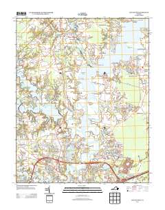
2013 Map of Chuckatuck
USGS Topo · Published 2013About this map
The Nansemond River dominates this Tidewater landscape, winding past numerous landings and wharves that hint at the region's long maritime history. Shoreline features such as Phillips Landing, Fergusons Wharf Light, and Trotman Wharf illustrate the persistent connection between these inland communities and the water. The map documents a transition from the established rural centers of Chuckatuck and Gloversville to newer residential developments like Brittany Farms and Lake Forest.
Find a feature on this map
100 named features on this map. Tap any name to fly to it.
Don’t see what you’re looking for? This feature index may not catch every label — zoom into the map to look around manually.
Map Details
Editions of this 2013 Chuckatuck Map
This is the sole edition of this map. No revisions or reprints were ever made.
Other maps of this area

1907 · Norfolk
USGS Topo · 1:125,000

1919 · Smithfield
USGS Topo · 1:62,500

1919 · Suffolk
USGS Topo · 1:62,500

1921 · Newport News
USGS Topo · 1:62,500

1940 · Lake Drummond
USGS Topo · 1:62,500

1944 · Windsor
USGS Topo · 1:31,680

1944 · Smithfield
USGS Topo · 1:24,000

1945 · Lake Drummond
USGS Topo · 1:62,500
1945 · Smithfield
USGS Topo · 1:31,680

1949 · Chuckatuck
USGS Topo · 1:24,000