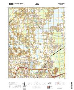
2019 Map of Chuckatuck
USGS Topo · Published 2019About this map
Chuckatuck Creek and the Nansemond River define the watery geography of this Virginia coastal landscape, where established settlements like Chuckatuck and Driver sit amidst a complex network of marshes and inlets. The map illustrates a region transitioning from rural landholdings to more structured residential developments, seen in communities such as Palmyra and Sadler Heights. The presence of large water bodies like the Western Branch Reservoir and Godwins Millpond underscores the importance of water management and heritage industries in this corner of Suffolk. Local history is anchored by several long-standing landmarks, including Benns Church and several burial sites like Little Zion Cem and Canaan Cem. From the reaches of the Great Dismal Swamp to the riverfront at Glebe Point, the map provides a look at the enduring environmental features that have shaped development near the Nansemond Shores.
Find a feature on this map
175 named features on this map. Tap any name to fly to it.
Don’t see what you’re looking for? This feature index may not catch every label — zoom into the map to look around manually.
Map Details
Editions of this 2019 Chuckatuck Map
This is the sole edition of this map. No revisions or reprints were ever made.
Other maps of this area

1907 · Norfolk
USGS Topo · 1:125,000

1919 · Smithfield
USGS Topo · 1:62,500

1919 · Suffolk
USGS Topo · 1:62,500

1921 · Newport News
USGS Topo · 1:62,500

1940 · Lake Drummond
USGS Topo · 1:62,500

1944 · Windsor
USGS Topo · 1:31,680

1944 · Smithfield
USGS Topo · 1:24,000

1945 · Lake Drummond
USGS Topo · 1:62,500
1945 · Smithfield
USGS Topo · 1:31,680

1949 · Chuckatuck
USGS Topo · 1:24,000