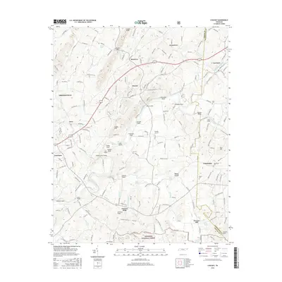
2016 Map of Chuckey
USGS Topo · Published 2016About this map
Rheatown and Chuckey anchor this Greene County landscape, where the Nolichucky River carves a winding path through a series of distinctive shoals. The river is characterized by numerous named hazards and crossings, including H Earnests Shoals, Gillespies Shoals, and Blaines Shoals, while Cane Island and Ripley Island break the current. This survey illustrates the settlement pattern common to this part of East Tennessee, with small communities like Philadelphia and Pleasant Hill connected by a dense network of local routes such as Chuckey Hwy and Old Stage Rd. To the south, the terrain rises toward Chestnut Ridge and the edge of the Cherokee National Forest, while the northern portion is dominated by the prominent peaks of Quaker Knobs. Genealogists will find several family-named burial grounds, including Fox Cem and Painter Cem, preserved alongside landmarks like Earnest Bridge and Glaze Bridge.
Find a feature on this map
205 named features on this map. Tap any name to fly to it.
Don’t see what you’re looking for? This feature index may not catch every label — zoom into the map to look around manually.
Map Details
Editions of this 2016 Chuckey Map
This is the sole edition of this map. No revisions or reprints were ever made.
Other maps of this area

1892 · Greeneville
USGS Topo · 1:125,000

1896 · Greeneville
USGS Topo · 1:125,000

1904 · Greeneville
USGS Topo · 1:125,000

1935 · Surgoinsville
USGS Topo · 1:48,000

1935 · Baileyton
USGS Topo · 1:24,000

1935 · Leesburg
USGS Topo · 1:24,000

1935 · Fall Branch
USGS Topo · 1:48,000
1935 · Jearoldstown
USGS Topo · 1:24,000

1936 · Greystone
USGS Topo · 1:24,000
1936 · Lake Davy Crockett
USGS Topo · 1:24,000