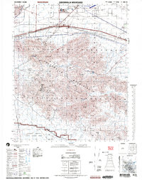
2002 Map of Chuckwalla Mountains
USGS Topo · Published 2004About this map
Chuckwalla Valley and the surrounding desert peaks are the focal point of this 2002 National Geospatial-Intelligence Agency survey, which illustrates the intersection of mid-century infrastructure and preserved wilderness. The small settlement of Desert Center sits alongside an underground pipeline, while the planned community around Lake Tamarisk features a golf course and mobile home park in the arid landscape. The map captures a transition between public and restricted lands, bordering the southeast corner of Joshua Tree National Park and the northern reaches of the Chocolate Mountain Aerial Gunnery Range. Notable local history markers include the Gruendikes Well (Site) and several remote Prospects, signaling the area's mining past. The Bradshaw Boundary and Edmund C Jaeger Nature Sanctuary further define the land use, where natural drainages like Dragon Wash and Alligator Wash carve through the basin toward the Chuckwalla Mountains.
Find a feature on this map
35 named features on this map. Tap any name to fly to it.
Don’t see what you’re looking for? This feature index may not catch every label — zoom into the map to look around manually.
Map Details
Editions of this 2002 Chuckwalla Mountains Map
This is the sole edition of this map. No revisions or reprints were ever made.
Other maps of this area

1940 · Frink
USGS Topo · 1:62,500

1940 · Iris Pass
USGS Topo · 1:62,500

1940 · Canyon Spring
USGS Topo · 1:62,500

1943 · Canyon Spring
USGS Topo · 1:62,500

1943 · Coxcomb Mountains
USGS Topo · 1:62,500

1944 · Eagle Tank
USGS Topo · 1:62,500

1944 · Chuckwalla Mountains
USGS Topo · 1:62,500

1944 · Coxcomb Mountains
USGS Topo · 1:62,500

1944 · Frink
USGS Topo · 1:62,500

1945 · Iris Pass
USGS Topo · 1:62,500