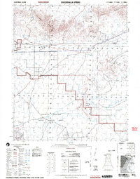
2002 Map of Chuckwalla Spring
USGS Topo · Published 2004About this map
The Chocolate Mountain Aerial Gunnery Range dominates the southern landscape of this California desert region, marking a significant military reservation boundary that separates public land from defense areas. Further north, the arid terrain is defined by the Chuckwalla Mountains and the Little Chuckwalla Mountains, with Graham Pass providing a natural corridor through the heights. The historic Bradshaw trail or road traverses the center, connecting scattered points of human presence such as Rainey Well and Indian Wells. This 2002 data reveals the intersection of resource extraction and geological interest, featuring the Paymaster Mine and several prospects near the Geode Beds and the Black Hills. Drainage patterns like Chuckwalla Wash and Milpitas Wash carve through the Smoketree Valley, illustrating the complex hydrology of the Colorado Desert.
Find a feature on this map
28 named features on this map. Tap any name to fly to it.
Don’t see what you’re looking for? This feature index may not catch every label — zoom into the map to look around manually.
Map Details
Editions of this 2002 Chuckwalla Spring Map
This is the sole edition of this map. No revisions or reprints were ever made.
Other maps of this area

1940 · Iris
USGS Topo · 1:62,500

1940 · Iris Pass
USGS Topo · 1:62,500

1942 · Blythe
USGS Topo · 1:250,000

1944 · Chuckwalla Mountains
USGS Topo · 1:62,500

1945 · Iris Pass
USGS Topo · 1:62,500

1945 · Iris
USGS Topo · 1:62,500

1952 · Mc Coy Spring
USGS Topo · 1:62,500

1952 · Sidewinder Well
USGS Topo · 1:62,500

1953 · Palo Verde Mountains
USGS Topo · 1:62,500

1953 · Quartz Peak
USGS Topo · 1:62,500