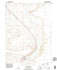
1990 Map of Chugwater
USGS Topo · Published 1995About this map
Chugwater serves as a focal point for this section of southeastern Wyoming, situated along the winding course of Chugwater Creek. The settlement's agricultural importance is physically marked by the presence of Grain Elevators near the railroad line, reflecting the high plains farming economy that defines the region. The landscape is characterized by expansive, elevated terrain such as Slater Flats and Chugwater Flats, which are occasionally broken by distinctive geological features like Chimney Rock and the drainage of Richeau Creek. Smaller named locales including Slater, Swan, and Lathrum appear as vital points in the local geography.
Find a feature on this map
18 named features on this map. Tap any name to fly to it.
Don’t see what you’re looking for? This feature index may not catch every label — zoom into the map to look around manually.
Map Details
Editions of this 1990 Chugwater Map
This is the sole edition of this map. No revisions or reprints were ever made.
Other maps of this area

1953 · Double L Ranch
USGS Topo · 1:24,000

1953 · Chugwater
USGS Topo · 1:24,000

1953 · Ferguson Corner
USGS Topo · 1:24,000

1953 · Bordeaux
USGS Topo · 1:24,000

1954 · Cheyenne
USGS Topo · 1:250,000

1958 · Cheyenne
USGS Topo · 1:250,000

1962 · Bristol Ridge NE
USGS Topo · 1:24,000
1962 · Whitcomb Hill
USGS Topo · 1:24,000
1963 · Dickinson Hill
USGS Topo · 1:24,000

1963 · C S Ranch
USGS Topo · 1:24,000