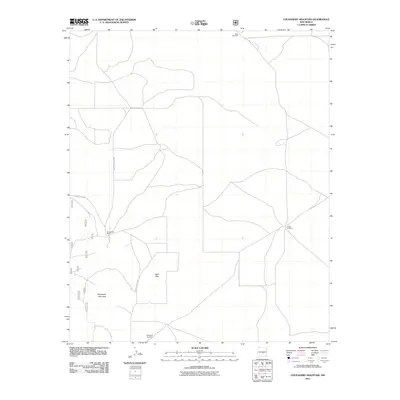
2011 Map of Chupadero Mountain
USGS Topo · Published 2011About this map
Chupadero Mountain and the Bald Hills dominate this section of the Lincoln County high country, where ranching life and sparse water resources dictate the landscape's organization. Remote infrastructure is anchored by essential water points like Soda Windmill and South Windmill, which support the scattered operations in this arid region. The presence of the Gnatkowski Ranch near the center of the sheet reflects the enduring legacy of private landholdings in this part of New Mexico. For those researching local family histories, the Carrabajal Cemetery serves as a significant genealogical landmark, located south of the main peaks. Access to these remote sites is provided by a network of secondary routes, including County Road A 036 and County Rd-A038, which navigate the winding terrain between ridges and valleys.
Find a feature on this map
15 named features on this map. Tap any name to fly to it.
Don’t see what you’re looking for? This feature index may not catch every label — zoom into the map to look around manually.
Map Details
Editions of this 2011 Chupadero Mountain Map
This is the sole edition of this map. No revisions or reprints were ever made.
Other maps of this area

1954 · Fort Sumner
USGS Topo · 1:250,000

1955 · Roswell
USGS Topo · 1:250,000

1958 · Fort Sumner
USGS Topo · 1:250,000

1958 · Roswell
USGS Topo · 1:250,000

1962 · Roswell
USGS Topo · 1:250,000

1973 · Ancho
USGS Topo · 1:24,000

1973 · Chupadero Mountain
USGS Topo · 1:24,000
1973 · White Oaks North
USGS Topo · 1:24,000

1973 · Jicarilla Peak
USGS Topo · 1:24,000

1980 · Corona
USGS Topo · 1:100,000