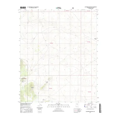
2017 Map of Chupadero Mountain
USGS Topo · Published 2017About this map
Chupadero Mountain rises above a landscape defined by the high-elevation peaks of the Jicarilla Mountains and the northern reaches of the Lincoln National Forest. This section of Lincoln County preserves a high-desert environment where topographic relief is significant, ranging from the depths of Hasperos Canyon to the summits of the Bald Hills. For those researching local history or genealogy, the Carrabajal Cem provides a specific point of ancestral interest, located south of the main peaks. The area is traversed by primitive routes such as Co Rd A036 and Co Rd 4036, which follow the natural contours of the land rather than a strict grid, reflecting the difficult terrain of central New Mexico. The map illustrates the sparsely populated nature of the region, where land use is dominated by forest management and open range.
Find a feature on this map
16 named features on this map. Tap any name to fly to it.
Don’t see what you’re looking for? This feature index may not catch every label — zoom into the map to look around manually.
Map Details
Editions of this 2017 Chupadero Mountain Map
This is the sole edition of this map. No revisions or reprints were ever made.
Other maps of this area

1954 · Fort Sumner
USGS Topo · 1:250,000

1955 · Roswell
USGS Topo · 1:250,000

1958 · Fort Sumner
USGS Topo · 1:250,000

1958 · Roswell
USGS Topo · 1:250,000

1962 · Roswell
USGS Topo · 1:250,000

1973 · Ancho
USGS Topo · 1:24,000

1973 · Chupadero Mountain
USGS Topo · 1:24,000
1973 · White Oaks North
USGS Topo · 1:24,000

1973 · Jicarilla Peak
USGS Topo · 1:24,000

1980 · Corona
USGS Topo · 1:100,000